


Boucle des 3 Croix de La Thuile

Valmeinier
User
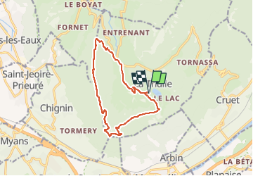

Length
12.6 km

Max alt
1292 m

Uphill gradient
640 m
Km-Effort
21 km

Min alt
767 m

Downhill gradient
639 m
Boucle
Yes
Creation date :
2020-06-17 06:23:13.883
Updated on :
2022-05-23 04:18:14.091
4h47
Difficulty : Very difficult

FREE GPS app for hiking
 SityTrail
IGN / Geographical institutes
SityTrail Plus
The world is yours!
About
Trail Walking of 12.6 km to be discovered at Auvergne-Rhône-Alpes, Savoy, La Thuile. This trail is proposed by Valmeinier.
Positioning
Country:
France
Region :
Auvergne-Rhône-Alpes
Department/Province :
Savoy
Municipality :
La Thuile
Location:
Unknown
Start:(Dec)
Start:(UTM)
269894 ; 5046029 (32T) N.
Comments